

ORIGINS TUTORIALS
Our Origins software is designed to get you started quickly and to be intuitive to use. With our detailed tutorials, you’ll get started in no time and can become a pro user quickly!
But before you watch our tutorials, the first thing we recommend you do is download our free trial version.
FIRST STEPS: 2-MINUTE TUTORIALS
There’s no easier way to learn working with Origins than with our 2-Minute Tutorials. The most important tools in Origins explained in an easy fashion – in 2 minutes or less!
TUTORIALS BY MODULE:
ORIGINS CORE MODULES
LAYOUTS & SECTIONS
Create floor plans and sections from your point cloud data in no time and with just a few clicks – including difference comparison and analysis, of course, and coloured if desired.
SKETCH
Measure areas, distances, 3D points, and angles. Staple photos and texts to specific parts of the point cloud or examine the point cloud more closely in the automatically created pano views.
ALIGN PROJECT
It is not uncommon to receive point cloud data not aligned the way you would need it for further processing. With our “Align Project” tool you can precisely align your data the way you want.
MERGER
Easily create positionally correct plans from your results. The created plans are scaled and have an attached coordinate file. This way you file your plans without losing the context of the object.
WEB-EXPORT
Pass on your results quickly and easily as a .html or PDF file with our Web Export. Of course, branded in your individual company design for a professional presentation of the data.
TRANSFORMATION CALCULATOR
Connect two projects in one coordinate system, georeference your project, or display the difference between older and current 3D data in one point cloud project.
TUTORIALS BY MODULE:
ORIGINS 3D MODULES (+REGISTRATION)
REGISTRATION
With our point cloud registration, you can register point cloud data using targets, natural points, or planes.
VECTORIZER
POINT CLOUD EXPORT
Export entire point clouds or even partial sections to the desired file format. Multiple conversions are no longer necessary!
MESH
Quickly create triangle-meshed digital terrain models and export them in the format you need.
VOLUMES
Fast volume determination is no longer a problem with this module. All international units are available!
SPACE WARP
No matter if polygonal, cylindrical, or curved objects, everything goes with our Space Wrap Tool!
TUTORIALS FOR ORIGINS PLUGINS
ORIGINS: FREQUENTLY ASKED QUESTIONS (FAQs)
Answers to frequently asked questions at a glance.
GENERAL QUESTIONS
How much does Origns Software cost?
We offer different software packages and payment models, which can vary depending on the country you live in. You can find an overview in our shop. We are also happy to advise you according to your needs and send you an individual offer. Simply contact our sales team: sales@pointcab-software.com
Are discounts available?
To be fair to our other customers, partners, and resellers, we, unfortunately, cannot offer a permanent discount. However, there are always special promotions, e.g. for certain trade fairs. We inform about such promotions via our newsletter.
How long can I use the trial version?
The trial license is valid for 25 working hours and it is limited to 3 projects. This means that the time only expires when Origins is open and in use. While Origins is closed, the timer stops.
Which CAD data formats can be exported?
With our plugins, you can transfer your point cloud data directly into Revit, Autocad, BricsCAD, ZWCAD or Archicad – without any prior export. For all other CAD software, you can find an overview of our data export abilities here.
Which data formats can be read and edited in Origins?
All common data formats can be read and edited in Origins. You can find an overview here.
Can Origins process photos, e.g. from drones?
There is a small “workaround” for this. To obtain a point cloud from camera images, you can use software solutions such as Agisoft Photoscan, Pix4D, or Sure. You can then read the point cloud calculated by these programs into Origins.
What requirements must my PC meet to be compatible with Origins?
As a general rule, the better your hardware, the faster Origins will calculate your jobs. Especially a higher number of cores and RAM have positive effects.
You can find detailed information here.
PLUGINS
PointCab Tab won't appear in BricsCAD Ribbon (PointCab 4Brics Plugin)
1. Close Bricscad, run the installer “BricsCAD-VBA-Runtime.exe” in “C:\Program Files\Bricsys\BricsCAD V.x en_US\VBA” then reopen Bricscad.
2. In case the plugin is still won’t appear, write “appload” in command line, and then set “Autoload” to ON for ‘PC4BCAD.dll’ and ‘PCResources.dll’.
Bonus Tip : Make sure the ribbon is visible in BricsCAD. In case it is not, write Ribbon in Command line to activate.
ERROR CODES
The dongle licence is not recognised.
This could be due to one of the following issues:
– The dongle is not recognized by the PC as a normal USB stick and displayed in My Computer. Please test if the dongle works on another USB port on your computer.
– There is no valid PointCab license on the dongle. Please check if your license is up to date.
– Anti-virus software is blocking access to the dongle. Please switch off the anti-virus software and try again.
If these solutions do not work, please contact our support team.
The online licence is not recognised.
This could be due to one of the following issues:
– Your computer does not have a stable internet connection. Please check this.
– There is no valid PointCab licence installed. If you have a valid support contract, the licence will be downloaded automatically. Please check your licence.
– Someone else is currently using your licence. If you share your licence with, for example, a colleague, please check if they are currently using PointCab.
If none of these solutions solve the problem, please contact the PointCab support.
The MAC licence is not recognised.
The MAC address of the computer has probably been changed.
Please open “Help > Licence Information” in PointCab and send us the correct MAC address.
Error code 203, 205, 211 or 214 during import
Error code 203:
– Eighter: File is not in the local storage location. Please place the file in a local storage location.
– Or: Umlaut characters such as ä, ü, ö are used in the file path. Please change the file pathname.
Error code 205:
The path to the files does not contain letters defined in ASCII code or is too long. Unfortunately, we cannot work around this because the respective manufacturers of the interfaces do not take this into account.
Error code 211:
One of the scans in the project file seems to be defective. Please check the scan panoramas in the associated standard program.
Error code 214:
The Faro Scene version you used to create the project is more recent than your currently installed Faro SDK. Please download the Faro SDK from the Faro website or write to our support to get the latest version.
The HTML file from the web export cannot be created
Possible error causes:
– The file is still open in another program.
– The template for HTML is missing in “Settings”. Please go to “File->Restore default setting”. If it still does not work, please contact our support.
The pano images in the HTML file are not displayed in the browser
Possible error causes:
• If you have selected “Bubble” for the panoramas, you need the Flash plugin in your browser. Please update or reinstall your Flash plugin and set the permissions if necessary. Alternatively, please export the panoramas with the “Planar” setting.
• The browser blocks access to the Adobe Flash plug-in. Please change in the settings of the browser and give the access right to locally stored HTML files.
If you still get an error message, please contact our support.
During data import it is displayed that .lsproj or .fws is empty
Possible causes of error:
– The data is not located locally on the computer. Please save the data to a local storage location.
– FARO SCENE is still open while PointCab is running. Please close FARO SCENE.
– The .lsproj or .fws file may be corrupted. Open the FARO project in FARO SCENE and check in the surface view if the scans can be displayed completely.
– The .lsproj or .fws file was not saved correctly. Please open the FARO project in FARO SCENE and save the FARO project again.
If none of these points solve the problem, please contact our support team.
LICENSING ISSUES
My application is not recognized. What can i do?
Please check the following points:
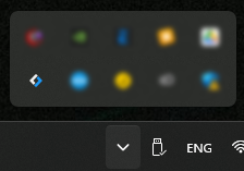
- Is LicTrustManager running at all? Open the arrow for hidden applications in the taskbar at the bottom right: Is the LicTrust icon displayed here? (blue/white rectangular symbol?)
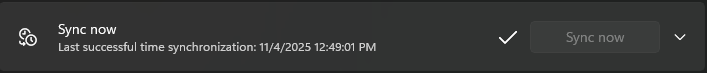
- Ensure that the computer’s time is up to date. Open https://www.time.gov/ or https://time.is/ in your internet browser and compare it to your computer clock. If there is a time difference, go to Windows settings under “Time and language > Date and time” and click “Sync now.”
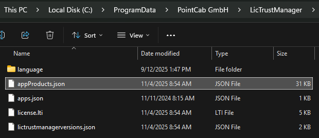
- Make sure LicTrustManager can establish an internet connection. Verify by deleting the file appProducts.json in path %programdata%/PointCab GmbH/LicTrustManager and whether this will be downloaded again after restarting Origins
- If you are using a proxy – write to us:
support@pointcab-software.com
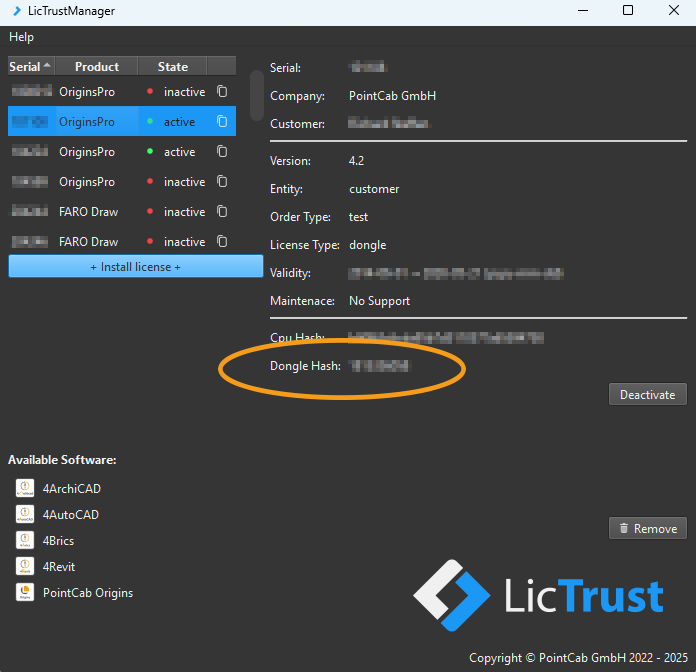
- If you are using a dongle, make sure that the “Dongle Hash” is displayed in the LicTrustManager application.
If none of these points solve the problem, please contact PointCab Support directly:
support@pointcab-software.com
TALK TO AN EXPERT
Would you like to find out more about PointCab and our Software in a personal meeting or do you have another request?
Just fill out the form below and our team will get back to you as soon as possible.
Want to keep up with the latest pointCab news?
Then follow us on Social Media or subcribe to our newsletter!