Laser scanning technology helps preserve and repurpose a historic masonry building in Crete

blank

Laser scanning technology helps preserve and repurpose a historic masonry building in Crete

blank

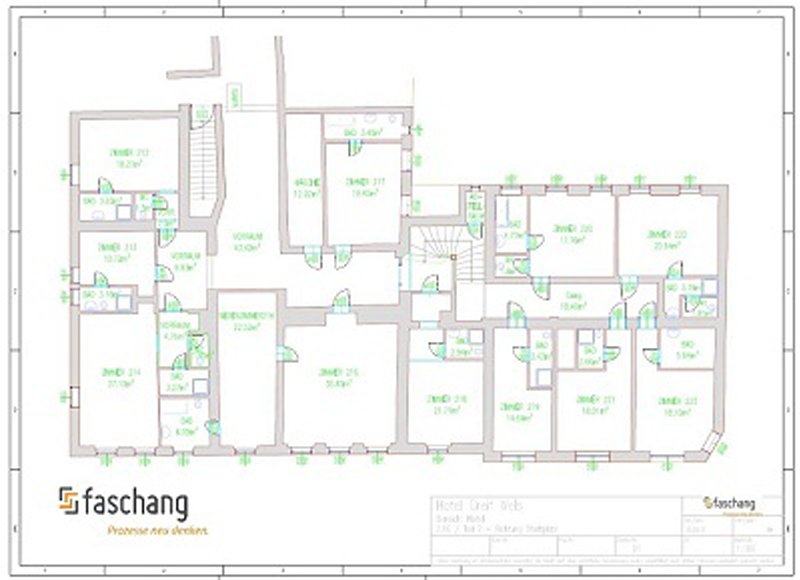
Postgraduate students at the Technical University of Crete used a combination of a Trimble Laser Scanner, PointCab Origins Pro, and Autocad to obtain and document the exact geometry of a historic masonry structure with the purpose of its structural rehabilitation.

The island of Crete, Greece is known for its beautiful landscape and rich history. It’s the birthplace of the first European advanced civilization, the Minoans, and was shaped by the Mycenaeans, Romans, Osmans, and many more. The traces of these cultures can still be found all across the island in different archeological remains.

blank

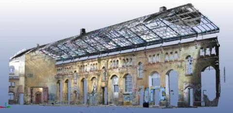
One of them is a two-century-old residential masonry, built during the Osman rule. It has been abandoned for the last 70 years and is the former residence of the wealthy Seimeni family. As one of the few remaining buildings of that type of local architecture in the region, it bears great historic value. In order to preserve and repurpose the building, exact documentation of its geometry was required, among other factors, in order to assess its structural integrity and the degree of necessary strengthening interventions. The building is planned to be restored in the next years and to be used as a local folk art museum.

blank
blank

Postgraduate student Eirini Chorianopoulou, supervised by Professors Maria Stavroulaki and Nikos Skoutelis decided to exploit the benefits of the latest laser scanning technology available. Since there were parts of the building that could not be approached and a distant measurement technique was needed, using simpler tools and techniques would not suffice. Therefore, an accurate digital representation of the building in its condition before the restoration could be captured. 

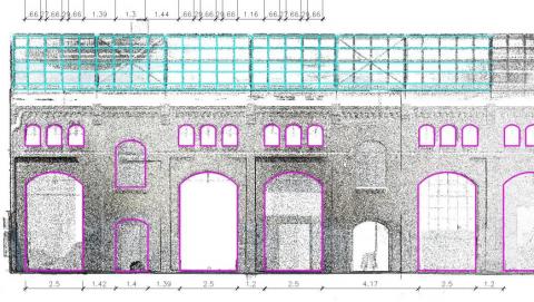
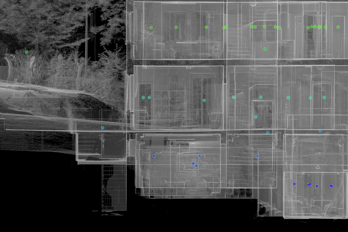
This will give future visitors the chance to understand and compare the prior and current state and appreciate the work that will be done in order to preserve the authenticity of the structure after its restoration. With the purpose to obtain the geometric properties of the structure, the Trimble X7 3D laser scanner was employed. A number of 25 scans were used to generate the point cloud. All the data was imported as e57 format files and edited in PointCab Origins Pro. Accurate plans, sections, and elevations of the structure were created at all necessary levels and were exported as .dwg files for further editing in Autocad. Postgraduate researcher Evangelos Nitadorakis, responsible for handling the point cloud evaluation, found himself satisfied with the results that the use of PointCab’s Origins software provided: 

blank

“The accuracy of the generated sections allowed the identification and quantification of pathology indicators such as wall inclinations not visible with the human eye and remote measurements in parts of the structure that are not easily accessible. In addition, the delta analysis tool helped to distinguish even the slightest deviations in vertical levels. Furthermore, with a proper combination of all the data from Origins, an exact 3D model of the structure was created in a FEM analysis software and structural and dynamic analysis were conducted in order to assess the fragility of the structure under various loading cases. Employing PointCab Origins, we appreciated the easy handling, the speed of data processing, and the quality of the outcomes.”

blank
blank

3D rendering of a historic commercial hall

blank

Laserscanning Architecture uses PointCab Origins in AutoCAD Architecture

The company Laser Scanning Architecture used the FARO 3D laser scanner for the three-dimensional acquisition of a historic commercial hall. The 3D data created was evaluated using AutoCAD Architecture and PointCab Origins. The scan data was analyzed in both photo mode and pixel mode using FARO Scene software. In the model, analyses and geometric allowances were performed in colored panoramic views. Perspectives could be freely selected and partial areas of the model could be hidden as desired.

Using PointCab Origins, a 2D analysis was realized in AutoCAD Architecture. For this purpose, orthographic 2D views of the existing structure were created from any position in the model using PointCab Origins. This laid the foundation for efficient replanning. The advantages were: orthographic 2D images of the inventory, as well as freely selectable positions in the scan. The inventory could be quickly captured in detail (cornices, stone formats, etc.). The resulting highly accurate dimensioning, formed the basis for efficient redesign, including overdrawing of component edges. PointCab Origins results were used to create plans, elevations, sections and 3D BIM models. Images could be extracted from the point cloud. The client was able to quickly view and use the information thanks to the web export.

WHY POINTCAB ORIGINS?

Software Speed

Even the most extensive point cloud data can be evaluated easily and quickly with PointCab Origins.

Direct workflow to AutoCAD

The information of the evaluated point cloud data could be easily and quickly transferred to AutoCAD.

Proximity to support

PointCab’s support is characterized by comprehensive expertise and individual attention.

Fast point cloud evaluation with PointCab Origins and Autodesk AutoCAD Architecture.
Laser Scanning Architecture
Jun. 2013

About Laser Scanning Architecture

As a formerly classic architectural office, we specialized in 3D laser scanning in 2010. Since then, the demand has increased so much that we are now only active in 3D surveying. Managing director Johannes Rechenbach has a working experience of more than 30 years as a freelance architect and has been running his own architectural office in Hannover for 20 years.

During this time, we have learned many times that a thorough survey of the existing building is always the basis for a successful remodeling project. The precise laser scanning therefore offers the perfect basis for all projects of building in existing contexts. https://www.laser-scanning-architecture.com

Thyssenkrupp

ThyssenKrupp

Measurement of an automotive production plant - ThyssenKrupp

The company ThyssenKrupp was faced with the task of creating an efficient and complete measurement of an existing automotive production plant in a short time. The priority was to quickly transfer the scan results to existing CAD systems such as AutoCad, FactoryCad or RobCad for further processing. By surveying with 3D laser scanning technology, a real image of the entirety of all installations was created in a single measurement, giving the project the necessary planning reliability.

In the next step, a floor plan was calculated from the scan data using PointCab Origins. This was available to the engineers as a basis for planning on the very next day of the measurement and could be further processed in existing CAD systems without additional training on the topics of laser scanning and handling point clouds. An additional added value results from the fact that the independent file format of PointCab Origins enables the data to be made available to other partners.

WHY POINTCAB ORIGINS?

Software Speed

Even the most extensive point cloud data can be evaluated easily and quickly with PointCab Origins.

Direct workflow to CAD software

The information of the evaluated point cloud data can be easily and quickly transferred to CAD programs.

Proximity to support

PointCab’s support is characterized by comprehensive expertise and individual attention.

Thanks to PointCab Origins, we were able to perform layout matching completely without modeling.
ThyssenKrupp Drauz Nothelfer GmbH
Dez. 2018

About ThyssenKrupp System Engineering

Thyssenkrupp System Engineering GmbH is an internationally active manufacturer of various components for the automotive industry’s body and powertrain process chains. https://www.thyssenkrupp-system-engineering.com/

Plant documentation in gas supply

kessel

Acquisition of complex piping systems – Export of precise dimensions

Niederreihnische Gas-Technik GmbH (NieGaTec) is a partner of the energy industry. Managing Director Klaus Jäger invested in the acquisition of a laser scanner in 2010 in order to improve his measurements. The complex pipeline structures in particular can be optimally recorded with the laser scanner. After purchasing the hardware, the question arose as to the optimal software for the rapid evaluation of the measurements. In the utility industry, 2D plans still dominate as a basis for work. Pipe runs are represented by line connections and gate valves, valves and other installations are indicated by symbols. Therefore, it was important for NieGaTec to quickly convert the 3D measurements back into layouts and sections.

After researching the market, the professionals chose PointCab Origins software because its ease of use and layout representation best met the needs of the gas industry. The layouts are read into AutoCAD through the PointCab Origins CAD export and drawn up by the staff. In this process, the symbol libraries developed by NieGatec can be used in their entirety. The interaction of laser scanning technology and PointCab Origins now enables NieGatec GmbH to guarantee its customers fast and precise measurements.

WHY POINTCAB ORIGINS?

Software speed

Even the most extensive point cloud data can be evaluated easily and quickly with PointCab Origins.

Direct workflow to AutoCAD

The information of the evaluated point cloud data can be easily and quickly transferred to AutoCAD.

Proximity to support

PointCab’s support is characterized by comprehensive expertise and individual attention.

Simply ingenious software for creating piping plans from our laser scanning projects.
Niederrheinische Gas-Technik GmbH
Jun. 2013

About Niederrheinische Gas-Technik GmbH

Niederreihnische Gas-Technik GmbH (NieGaTec) is a partner of the energy industry. The company provides versatile engineering services for utilities in the energy industry. These include many municipal utilities and gas suppliers. For the documentation and planning of plants, an as-built survey is indispensable. This often involves gas distribution systems, gas pressure regulating stations (GDR) and gas pressure regulating metering stations (GDRM). www.niegatec.de

Acquisition of a limestone crushing plant

blank

Plant engineering - ThyssenKrupp Fördertechnik GmbH

On behalf of a cement plant in the Middle East, ThyssenKrupp Fördertechnik GmbH used PointCab Origins to capture the data of an existing limestone crushing plant for plant engineering purposes by means of laser scanning. The goal of ThyssenKrupp Fördertechnik GmbH was to compare the 3D laser scan data with an existing 3D CAD model of the plant design in order to concretely plan an expansion of the plant.

A laser scanner from the company FARO was used to scan a conveyor belt approximately 160 meters long for the plant design. The conveyor belt begins underground and ends at a discharge station 6 meters above the ground. The conveyor belt passes through several silos. The 3D model provided a real image of the plant and highly accurate dimensions, which provided an optimum planning basis for the plant expansion. Conversion work could be visualized concretely and finally on the PC, which greatly limited the risk of collisions during execution. The acquisition of the conveyor belt was very fast. The time required for the acquisition from different heights amounted to 3 days. The conveyor belt only had to be stopped for 2 hours. The result was 40 scans that were registered and evaluated with PointCab Origins directly on site. This ensured that all the required data was recorded and that a second survey (and thus disruption of the workflow) was not necessary.  The sections created in PointCab Origins were then used for further processing in AutoCAD.

WHY POINTCAB ORIGINS?

Software speed

Even the most extensive point cloud data can be evaluated easily and quickly with PointCab Origins.

Direct workflow to AutoCAD

The information of the evaluated point cloud data can be easily and quickly transferred to AutoCAD.

Proximity to support

PointCab’s support is characterized by comprehensive expertise and individual attention.

Evaluate laser scanner results quickly and easily directly on site. Awesome!
ThyssenKrupp
Dez. 2018

About ThyssenKrupp

As an international group of companies, we develop technologies and solutions for future market and customer needs.

https://www.thyssenkrupp.com/

Surveying of 12.000sqm of inhabited floor space

blank

Surveying 12,000 m² of Inhabited Floor Space:
Why a Complete 3D As-Built Survey Was Needed

The project involved surveying more than 12,000 m² of inhabited floor space, including a hotel, a municipal theatre, offices and residential units.

For such mixed-use buildings, reliable and up-to-date as-built plans are essential — especially when fire-protection documentation is required.
Because existing plans were incomplete and the building was in active daily use, a full digital survey became the most efficient and accurate solution.

The Challenge: Surveying a Large, Inhabited Mixed-Use Building

Inhabited buildings present extra challenges compared to empty or unused structures:

  • Continuous operation: Hotel guests, office staff and residents could not be disturbed.
  • Mixed layouts: Hotels, theatres, offices and residential spaces each have different room structures, escape routes and technical areas.
  • Complex circulation: Theatre back-of-house zones, technical rooms and varying ceiling heights complicate manual measurement.
  • Large total area: Over 12,000 m² had to be captured consistently across several building sections and levels.

To meet these challenges, the team selected a high-precision, fast and non-intrusive method: 3D laser scanning.

How the Survey Was Completed: FAST Laser Scanning With Only Two People

The surveying was executed by Faschang Service & Management GmbH, who used a FARO Focus3D laser scanner to capture every part of the building.
Despite the size and complexity, the entire scanning process was completed:

  • in 45 hours,
  • using just two employees.

This shows the efficiency of laser scanning in inhabited environments: the scanner captures geometry quickly, quietly and with minimal disruption to regular building operations.

Point Cloud Evaluation in PointCab Origins: From Scan to Plans

Once the point cloud was created, it was processed in PointCab Origins, where essential deliverables were generated automatically:

  • floor plans,
  • site plans
  • sections
  • orthophotos.

Using these true-to-scale orthophotos, the team produced the required as-built drawings and fire-protection plans in AutoCAD.

Because all data originated from the point cloud, the resulting plans were consistent, accurate and based on the current state of the entire 12,000 m² complex.

The perfect software solution for efficient creation of orthophotos and as-built plans.
Faschang Service & Management GmbH
Jun. 2013

Digital Data for Future Use: One Scan, Many Applications

A major advantage of the workflow is that the complete point cloud was stored as a digital record.
This proved useful later: when façade drawings were needed for extension planning, the team was able to generate them directly from the existing scan — without additional site visits.
One scan created a long-term data resource that can support fire protection, renovation, design updates or further documentation tasks.

Want to keep up with the latest pointCab news?

Then follow us on Social Media or subcribe to our newsletter!