Measurement of a packing plant

blank

Engineering company Kvejborg – Food industry

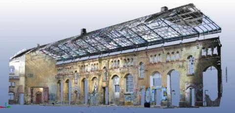
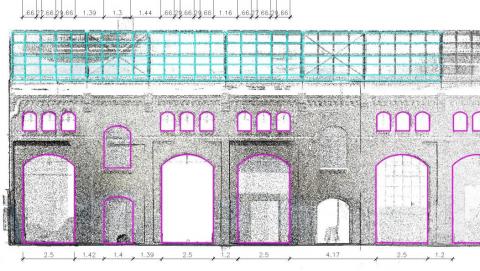
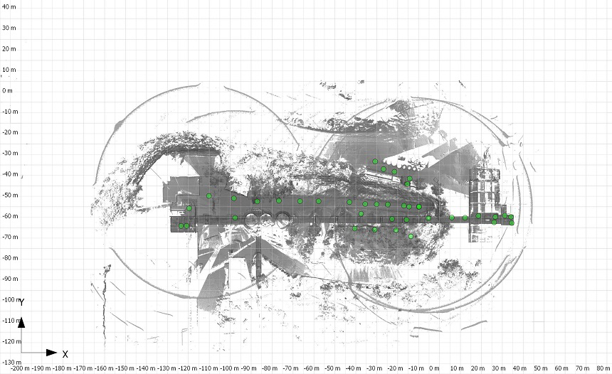
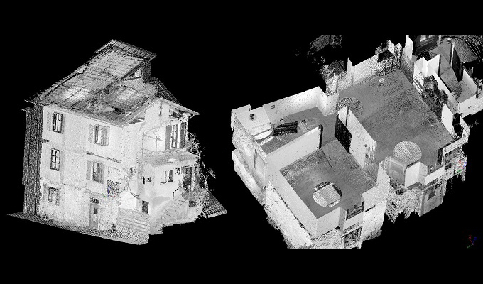
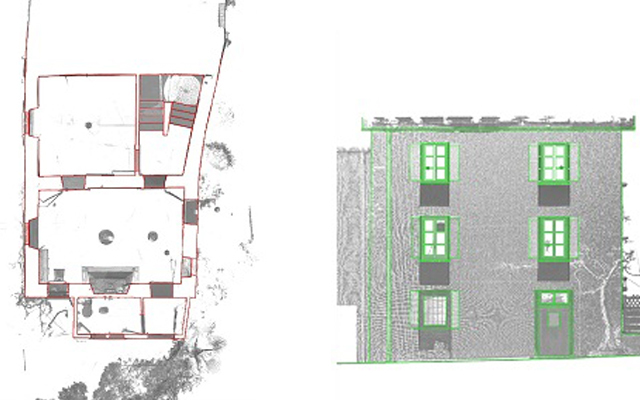
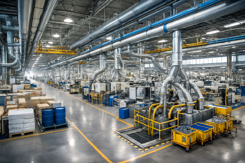
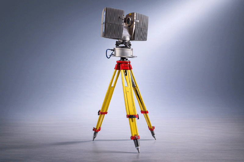
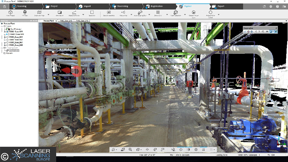
In a pilot project, the task was to measure two robot workstations in a large bakery during ongoing production. The existing robot tools were to be submerged in order to optimize the overall process. The bakery’s production runs in three shifts. A very fast recording method was needed to measure the packaging workstations, since stopping production involves high costs. The solution was to stop the robot cells individually for a short time. Some employees of the large bakery then manually stacked the fresh baked goods. The time required for the detailed measurement of the interior using a laser scanner was only 10 minutes per cell.  This meant that there were no disruptive influences on the production process.

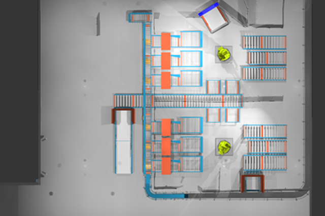
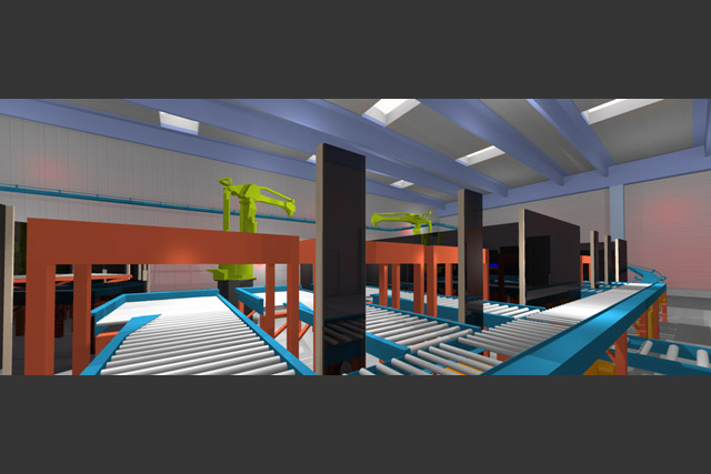
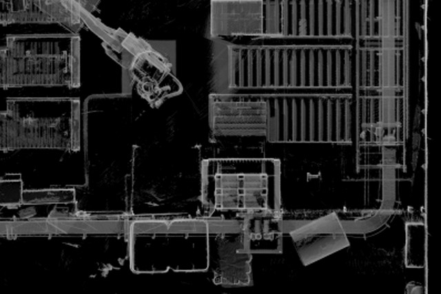
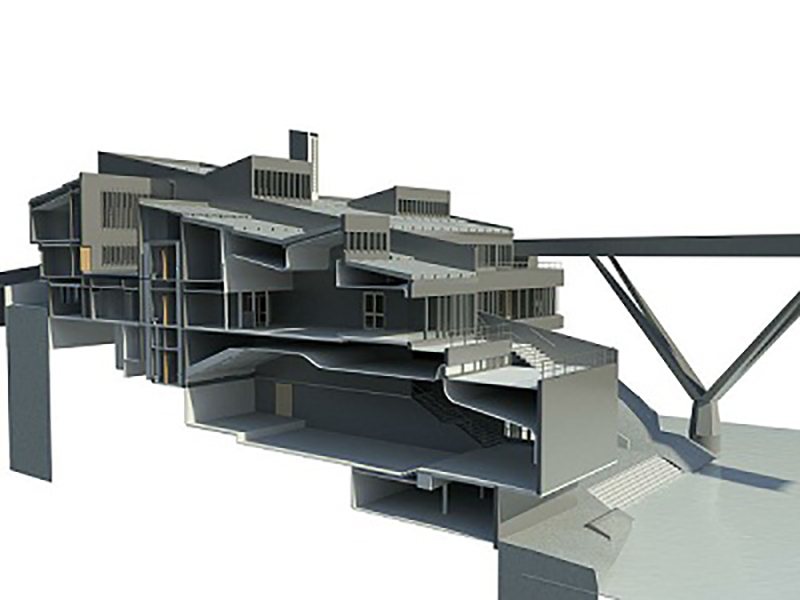
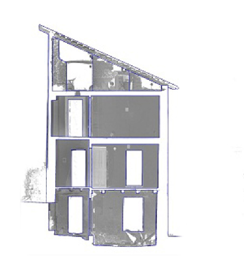
The subsequent data processing with PointCab Origins then generated the layouts, which were available to the plant planners the very next day. This is where the compatibility of PointCab Origins paid off. In contrast to a point cloud, the plans could be easily transferred to the CAD systems Solidworks and Inventor for further processing. Complex plants very often involve several different technical planners. PointCab Origins enables the planning office Kvejborg to make the generated planning basis available to all partners involved in the planning process simultaneously – without additional costs.

WHY POINTCAB ORIGINS?

Software Speed

Even the most extensive point cloud data can be evaluated easily and quickly with PointCab Origins.

Direct workflow to CAD software

The information of the evaluated point cloud data can be easily and quickly transferred to the CAD software.

Proximity to support

PointCab’s support is characterized by comprehensive expertise and individual attention.

With PointCab Origins, our customers can use the laser scanning results directly in Inventor.
Engineerringunternehmen Kvejorg
Jun. 2013

About Kvejborg

The Danish company Kvejborg is a Scandinavian design office in the plant engineering sector that is involved in the design of machines, tools and robot applications. Laser scanning technology is an integral part of the company and is used, among other things, as a design basis in special machine construction. https://kvejborg.dk/

3D rendering of a historic commercial hall

blank

Laserscanning Architecture uses PointCab Origins in AutoCAD Architecture

The company Laser Scanning Architecture used the FARO 3D laser scanner for the three-dimensional acquisition of a historic commercial hall. The 3D data created was evaluated using AutoCAD Architecture and PointCab Origins. The scan data was analyzed in both photo mode and pixel mode using FARO Scene software. In the model, analyses and geometric allowances were performed in colored panoramic views. Perspectives could be freely selected and partial areas of the model could be hidden as desired.

Using PointCab Origins, a 2D analysis was realized in AutoCAD Architecture. For this purpose, orthographic 2D views of the existing structure were created from any position in the model using PointCab Origins. This laid the foundation for efficient replanning. The advantages were: orthographic 2D images of the inventory, as well as freely selectable positions in the scan. The inventory could be quickly captured in detail (cornices, stone formats, etc.). The resulting highly accurate dimensioning, formed the basis for efficient redesign, including overdrawing of component edges. PointCab Origins results were used to create plans, elevations, sections and 3D BIM models. Images could be extracted from the point cloud. The client was able to quickly view and use the information thanks to the web export.

WHY POINTCAB ORIGINS?

Software Speed

Even the most extensive point cloud data can be evaluated easily and quickly with PointCab Origins.

Direct workflow to AutoCAD

The information of the evaluated point cloud data could be easily and quickly transferred to AutoCAD.

Proximity to support

PointCab’s support is characterized by comprehensive expertise and individual attention.

Fast point cloud evaluation with PointCab Origins and Autodesk AutoCAD Architecture.
Laser Scanning Architecture
Jun. 2013

About Laser Scanning Architecture

As a formerly classic architectural office, we specialized in 3D laser scanning in 2010. Since then, the demand has increased so much that we are now only active in 3D surveying. Managing director Johannes Rechenbach has a working experience of more than 30 years as a freelance architect and has been running his own architectural office in Hannover for 20 years.

During this time, we have learned many times that a thorough survey of the existing building is always the basis for a successful remodeling project. The precise laser scanning therefore offers the perfect basis for all projects of building in existing contexts. https://www.laser-scanning-architecture.com

Thyssenkrupp

ThyssenKrupp

Measurement of an automotive production plant - ThyssenKrupp

The company ThyssenKrupp was faced with the task of creating an efficient and complete measurement of an existing automotive production plant in a short time. The priority was to quickly transfer the scan results to existing CAD systems such as AutoCad, FactoryCad or RobCad for further processing. By surveying with 3D laser scanning technology, a real image of the entirety of all installations was created in a single measurement, giving the project the necessary planning reliability.

In the next step, a floor plan was calculated from the scan data using PointCab Origins. This was available to the engineers as a basis for planning on the very next day of the measurement and could be further processed in existing CAD systems without additional training on the topics of laser scanning and handling point clouds. An additional added value results from the fact that the independent file format of PointCab Origins enables the data to be made available to other partners.

WHY POINTCAB ORIGINS?

Software Speed

Even the most extensive point cloud data can be evaluated easily and quickly with PointCab Origins.

Direct workflow to CAD software

The information of the evaluated point cloud data can be easily and quickly transferred to CAD programs.

Proximity to support

PointCab’s support is characterized by comprehensive expertise and individual attention.

Thanks to PointCab Origins, we were able to perform layout matching completely without modeling.
ThyssenKrupp Drauz Nothelfer GmbH
Dez. 2018

About ThyssenKrupp System Engineering

Thyssenkrupp System Engineering GmbH is an internationally active manufacturer of various components for the automotive industry’s body and powertrain process chains. https://www.thyssenkrupp-system-engineering.com/

Plant documentation in gas supply

kessel

Acquisition of complex piping systems – Export of precise dimensions

Niederreihnische Gas-Technik GmbH (NieGaTec) is a partner of the energy industry. Managing Director Klaus Jäger invested in the acquisition of a laser scanner in 2010 in order to improve his measurements. The complex pipeline structures in particular can be optimally recorded with the laser scanner. After purchasing the hardware, the question arose as to the optimal software for the rapid evaluation of the measurements. In the utility industry, 2D plans still dominate as a basis for work. Pipe runs are represented by line connections and gate valves, valves and other installations are indicated by symbols. Therefore, it was important for NieGaTec to quickly convert the 3D measurements back into layouts and sections.

After researching the market, the professionals chose PointCab Origins software because its ease of use and layout representation best met the needs of the gas industry. The layouts are read into AutoCAD through the PointCab Origins CAD export and drawn up by the staff. In this process, the symbol libraries developed by NieGatec can be used in their entirety. The interaction of laser scanning technology and PointCab Origins now enables NieGatec GmbH to guarantee its customers fast and precise measurements.

WHY POINTCAB ORIGINS?

Software speed

Even the most extensive point cloud data can be evaluated easily and quickly with PointCab Origins.

Direct workflow to AutoCAD

The information of the evaluated point cloud data can be easily and quickly transferred to AutoCAD.

Proximity to support

PointCab’s support is characterized by comprehensive expertise and individual attention.

Simply ingenious software for creating piping plans from our laser scanning projects.
Niederrheinische Gas-Technik GmbH
Jun. 2013

About Niederrheinische Gas-Technik GmbH

Niederreihnische Gas-Technik GmbH (NieGaTec) is a partner of the energy industry. The company provides versatile engineering services for utilities in the energy industry. These include many municipal utilities and gas suppliers. For the documentation and planning of plants, an as-built survey is indispensable. This often involves gas distribution systems, gas pressure regulating stations (GDR) and gas pressure regulating metering stations (GDRM). www.niegatec.de

Acquisition of a limestone crushing plant

blank

Project Overview: Accurate Data for Industrial Plant Expansion

The As-Built Documentation of Industrial Facilities is an increasingly important application in surveying. In this project, the planning of a plant expansion was commissioned. Specifically, it involved a limestone crushing plant at a cement factory in the Middle East. ThyssenKrupp Fördertechnik GmbH used 3D laser scanning with PointCab Origins to capture the existing facility in detail. The goal was to compare the laser scan data with an existing 3D CAD model and create a reliable basis for planning the upcoming plant extension—something that would not have been feasible without precise as-built documentation.

3D Laser Scanning for Efficient and Non-Disruptive Data Capture

A FARO laser scanner was used to capture a conveyor belt system approximately 160 m in length, starting underground and ending at a discharge point about six metres above ground level. The conveyor passes through several silos and multiple height levels, making conventional measurement methods inefficient and time-consuming.

Using 3D laser scanning allowed the system to be documented with minimal disruption to ongoing operations:

  • Data acquisition was carried out over three days.
  • The conveyor belt needed to be stopped for only two hours in total.
  • 40 individual scans were captured and registered and evaluated directly on site using PointCab Origins.

This ensured complete coverage of the facility and eliminated the need for repeat site visits or additional shutdowns.

Evaluate laser scanner results quickly and easily directly on site. Awesome!
ThyssenKrupp
Dez. 2018

Processing the Point Cloud and AutoCAD

The sections and evaluations generated in PointCab Origins formed the basis for further planning and design.
After on-site registration, the processed point cloud data was transferred into AutoCAD for continued CAD work. This enabled planners and engineers to work directly with accurate, real-world geometry and align the planned plant expansion with the existing structure.

Benefits of the Workflow As-Built Documentation of Industrial Facilities

This project highlights the advantages of combining 3D laser scanning with point cloud processing for industrial plants:

  • Efficiency: Large and complex plant components can be captured quickly with minimal downtime.
  • Data accuracy: The point cloud reflects the actual condition of the facility with high precision.
  • Planning reliability: Accurate measurements help prevent clashes and design errors during plant expansion.
  • Seamless CAD workflow: Results integrate smoothly into standard CAD environments such as AutoCAD.

For industrial facilities operating under tight production schedules, this approach provides a reliable and practical foundation for modification and expansion projects.

Want to keep up with the latest pointCab news?

Then follow us on Social Media or subcribe to our newsletter!

Facade elevation of a listed industrial building

blank

Requirements: Facade Documentation of Listed Building

In Magdeburg, a historic industrial building subject to preservation orders was undergoing conversion into residential loft apartments. To comply with heritage requirements and support renovation planning, highly accurate, true-to-scale documentation of the building’s facades was essential. Traditional measurement approaches were not feasible due to the narrow working space and the structure’s height, so a 3D laser scanning survey was commissioned. The 3D laser scanning survey, as well as the processing and modeling of the point cloud data was carried out by Laserscanning Europe.

Challenges of Capturing a Listed Facade

The building’s complex geometry presented multiple challenges:

  • The facades reach up to 17 m in height, making direct manual measurement risky and limited by space.
  • The east facade features multiple offsets and sloping sections, requiring detailed mapping to capture elements such as window surrounds and wall protrusions.
  • As a listed structure, all renovations must align with heritage preservation requirements, which demand accurate documentation of existing conditions before design can proceed.

These conditions made non-contact 3D laser scanning the only practical method to achieve comprehensive and precise data.

Survey Execution: 25 Scan Positions and Efficient Data Capture

The team performed a total of 25 laser scanner setups across the three principal facades, covering a facade area of 1,720 m². Only one surveyor was needed on site, and the total scanning time was approximately 5 hours.

The result was a dense and complete point cloud representing all facade details – including irregularities and features that are critical for both preservation and renovation planning.

The rapid creation of scaled orthophotos allowed for quick analysis in Geograf.
Eric Bergholz
CEO, Laserscanning Europe GmbH
Dez. 2018

From Point Cloud to Digital Plans Using PointCab Origins and Geograf

Once the laser scanning was completed, the raw point cloud data was processed with PointCab Origins:

  • True-to-scale orthophotos were generated automatically.
  • The orthophotos and extracted measurements were imported into the CAD system Geograf within one hour.
  • Detailed 2D plans, including facade drawings and crack documentation, were created at a 1:50 scale.

This workflow enabled architects and engineers to immediately begin modeling and detailed planning for renovation and conversion. The CAD deliverables supported both the artistic design and the technical compliance needed for a listed building.

Why Detailed Facade Documentation Matters for Preservation Projects

For any structure under heritage protection, understanding the existing condition – especially at high resolution – is vital:

  • Preservation orders require that original characteristics be respected in renovation.
  • Irregularities (cracks, offsets, sloping segments) must be precisely recorded before any intervention.
  • A digital record supports historical documentation and prevents speculative or inaccurate reconstruction.

By using 3D laser scanning and rapid orthophoto generation, the project team not only met the strict accuracy requirements but also sped up the planning process, saving time and reducing risk during subsequent project phases.

Want to keep up with the latest pointCab news?

Then follow us on Social Media or subcribe to our newsletter!

Surveying Dunelm House

dunelm house

Dunelm House: Why a Precise 3D Survey Was Needed

Dunelm House (1966) is Durham University’s well-known students’ union building. Designed in the post-war modernist style, it sits directly on the steep banks of the River Wear. Furthermore, it is connected to the equally iconic Kingsgate Bridge.

The structure is characterized by exposed concrete and terraced floor levels. A multi-angled, irregular roofscape follows the natural slope of the riverbank. This bold design makes Dunelm House architecturally significant  – and challenging to measure.
When leaks appeared across several roof areas, a detailed digital survey was needed. The aim was to document the current condition and guide the renovation.

The Challenge: Complex Roof and Difficult Site Conditions

The student building’s roof consists of intersecting levels, changing slopes, and unconventional angles. Combined with its sloping riverside location, this makes traditional measurement methods unreliable and slow.

To capture the structure accurately and efficiently, the project required a modern surveying approach capable of documenting every plane and surface with precision.

How the Survey Was Completed: Laser Scanning + GPS

The survey was carried out by Bury Associates Ltd using two FARO Focus3D laser scanners. To record the terrain and ensure accurate referencing across the entire site, the team also used total stations and GPS equipment.

This hybrid surveying method made it possible to capture:

  • the full exterior geometry of Dunelm House,
  • its complex multi-level roof structures,
  • and high-precision topographic context along the River Wear.

The result was a detailed point cloud covering the entire building and its surroundings.

We think PointCab Origins is the fastest way to extract plans and sections from point clouds.
Bury Associates Limited
Dez. 2018

From Point Cloud to 3D Model: Deliverables in Four Days

After the scanning process, the data was processed using PointCab Origins, which enabled the team to deliver complete documentation in just four days.
The deliverables included:

  • orthophotos,
  • 2D floor plans,
  • sections and elevations,
  • and a full 3D Revit model created from the processed Origins data.

By exporting PointCab’s results into Autodesk Revit, the project team gained a BIM-ready model with the accuracy needed to analyse the leaking roof and plan the renovation.

How the Digital Survey Supports the Renovation Process

The Dunelm House project shows how 3D laser scanning, precise site measurement, and point cloud processing can deliver fast, reliable results — even for buildings with complex shapes and challenging site conditions.

With the combination of FARO scanners, survey instruments, and PointCab Origins for evaluation, Bury Associates delivered a complete set of renovation-ready outputs, including a detailed Revit model.
This provided architects and engineers with a solid digital foundation for repairing and preserving one of Durham’s most distinctive architectural landmarks.

Want to keep up with the latest pointCab news?

Then follow us on Social Media or subcribe to our newsletter!

As-built documentation of an old house

As-Built Documentation of an Old House: Why a Complete 3D Laser Scan Was Essential

An old residential building in a village in the Swiss canton of Ticino lacked reliable, up-to-date building plans. To prepare renovation and restoration work, the engineering firm Geomatica Righitto (Lugano, Switzerland) was commissioned to do a full 3D as-built documentation.

Traditional plans were missing or outdated, and the building required precise measurements to support planning in CAD and BIM software.

Missing Plans, Irregular Geometry, and the Need for Precision

Older buildings rarely follow perfectly straight lines or standardized geometries. Over decades – or even centuries – walls may shift, floors may sag, and angles deviate from 90 degrees.

This means: assumptions based on symmetry or “standard” geometry can be highly misleading.

For renovation work, especially structural or restorative interventions, accurate data is crucial. Because no reliable plans existed for this house and its geometry was visibly irregular, a precise and complete measurement was essential, making 3D laser scanning the ideal method.

Survey: Faro Photon 120, Faro Scene, and Efficient On-Site Work

Geomatica Righitto used a FARO Photon 120 laser scanner to capture the entire building, including:

  • three façades,
  • the basement,
  • the roof,
  • and all four floors.

In total:

  • 29 scans,
  • 6 hours on site,
  • 3 survey specialists.

All scans were registered and merged in FARO Scene, ensuring correct alignment and a unified, consistent point cloud.

This point cloud became the complete digital representation of the building, including all the irregularities typical of older structures.

Point clouds are for engineers, plans for architects. PointCab Origins is the fastest connection between them.
Marzio Righitto
Engineer - Pastorelli SA
Dez. 2018

Processing the Point Cloud: Fast Extraction of Plans and Sections

Once the unified point cloud was ready, Geomatica Righitto used PointCab Origins to extract essential architectural outputs:

  • 4 floor plans
  • 3 façade plans
  • 20 building sections
  • Orthophotos for façades and interior walls

These automated extractions significantly reduced manual drafting work.
The final drawings — both as-built documentation and renovation plans — were delivered in a CAD/BIM-ready format for use in Archicad.

The entire processing workflow, including preparation for delivery, took about 8 hours.

What This Case Study Demonstrates

This project shows how even older buildings with irregular geometry and missing documentation can be comprehensively captured. Old buildings are rarely dimensionally perfect, but laser scanning captures reality exactly as it is, and the resulting point cloud becomes a trusted digital baseline.

The combination of FARO Photon 120, FARO Scene, and PointCab Origins enabled Geomatica Righitto to create reliable plans quickly –  giving architects and engineers the confidence they need to design renovations and restoration work effectively.

Want to keep up with the latest pointCab news?

Then follow us on Social Media or subcribe to our newsletter!

Renovation of an old farmhouse

blank

Project Overview: Precise Survey for Full Renovation Planning

In Wattenwil near Bern (Switzerland), a historic farmhouse that had fallen out of regular use due to high maintenance costs was scheduled for full renovation and reuse as a residential building. For this project, precise as-built documentation for renovation projects was required to support planning, design decisions and cost estimation.

Since no reliable plans existed, the architectural office AAP Atelier für Architektur und Planung AG was commissioned to carry out the 3D laser scanning survey and evaluation.

Why 3D Laser Scanning Was the Optimal Survey Method

Old farmhouses often have irregular geometry owing to historical construction techniques and settling over time. Traditional measurement methods can struggle to capture such complexity efficiently, and missing or inconsistent documentation increases planning risk. In this project, 3D laser scanning provided a precise and complete dataset suitable for detailed planning in CAD.

For this reason, a FARO Photon 120/20 laser scanner was used. Over two full days of on-site work, the team captured around 30 individual scans covering all important surfaces, including:

  • facades,
  • internal floor plans,
  • load-bearing structure,
  • and architectural details necessary for renovation planning.

The point cloud data was registered using reference targets to ensure spatial accuracy and full coverage of the building geometry.

We were able to easily use our FARO laser scanner data in ArchiCAD thanks to PointCab Origins.
AAP Atelier für Architektur und Planung AG
Dez. 2013

From Point Cloud to Planning Deliverables Using PointCab Origins and ArchiCAD

Once the raw scan data was collected, the exported point cloud was processed with PointCab Origins, enabling fast extraction of key deliverables:

Thanks to PointCab Origins’ workflow, these outputs were quickly read into the customer’s CAD system, Graphisoft ArchiCAD, where they served as the basis for further planning and material estimation. The clarity and accuracy of the extracted plans helped determine rehabilitation needs, material quantities, and cost implications early in the project.

The combination of scan capture and software evaluation significantly reduced manual drawing work and enabled planners to focus on design and implementation rather than re-measurements.

Why As-Built Documentation Is Essential for Renovation Projects

This farmhouse case demonstrates several clear advantages of using 3D laser scanning and point cloud processing for renovation:

  • Precise real-world geometry: captures every irregularity and construction detail that would otherwise be missed on paper plans.
  • Efficient workflow: rapid on-site scanning and fast post-processing deliver usable CAD data in a short timeframe.
  • Planning confidence: reliable digital data reduces risk when estimating effort and materials for big renovation decisions.
  • Seamless integration: outputs easily transfer to common CAD systems for further design and documentation.

For renovation projects of older buildings, especially those without current documentation, this approach is a strong foundation for both the design process and accurate cost planning.

Want to keep up with the latest pointCab news?

Then follow us on Social Media or subcribe to our newsletter!

Acquisition of factory halls

USER STORY

Acquisition of Factory Halls:
3D Laser Scanning for Complete Documentation

As part of a major industrial documentation project, the Interdisciplinary Competence Center for Old Buildings (InKA) of the University of Siegen carried out a full 3D laser scanning of factory halls covering approximately 10,000 m². The goal was to create reliable documentation for subsequent CAD modeling and planning in Graphisoft ArchiCAD.

Why Detailed Factory Acquisition Matters

Large factory halls and industrial plants contain extensive structural geometry as well as supply and disposal lines, machinery, and installations. Without precise as-built data, even well-intended renovation, retrofitting, or layout planning can suffer from:

  • geometry mismatches between the physical structure and the existing drawings
  • misaligned equipment due to outdated plans
  • planning delays due to manual re-measuring on-site

A modern 3D laser scan provides an accurate, coherent representation of the facility that eliminates guesswork and supports efficient engineering and design.

How the Factory Halls Were Surveyed: FARO Photon 80 and Point Cloud Capture

The survey covered approximately 10,000 m², using a FARO Photon 80 laser scanner. 

  • Total scans: 80
  • Total data volume: approx. 70 GB
  • Geometry captured: complete interior of the factory halls and all supply/disposal lines

This dense set of scans ensured full coverage and detailed capture of the existing infrastructure — even in areas with complex pipework or machinery.

Point Cloud Registration in FARO Scene

All individual scans were registered and merged using FARO Scene to produce a unified point cloud. This step ensures:

  • correct alignment across all scans
  • a single 3D dataset covering the entire facility
  • consistent coordinate referencing for export and further processing

A unified point cloud is the foundation for accurate plan extraction, CAD modeling and coordination between engineering teams.

The PointCab Origins plans can be easily processed in ArchiCAD without additional software.
University of Siegen
Jun. 2013

Deriving Accurate Plans and Sections from the Point Cloud

Once registered, the point cloud was evaluated in PointCab Origins. The software enabled rapid extraction of 2D plans and sections at any desired position through the point cloud. These derived outputs consisted of:

  • orthographic images scaled to real dimensions
  • tiling across multiple files to adapt the export size for different CAD systems
  • export formats readable by all major CAD/BIM platforms

PointCab Origins reduced the raw data to manageable file sizes without sacrificing accuracy, which made it possible to transfer directly into Graphisoft ArchiCAD for further modeling.

Why 3D Acquisition Is Valuable for Industrial Facilities

This case highlights the core strengths of laser scanning in industrial environments:

  • Complete coverage: Includes structural elements, machinery, and services in a single dataset.
  • High accuracy: Up to 2 mm per pixel in scaled outputs allows precise modeling.
  • Flexible export: Tiling and export options make datasets usable in virtually all CAD systems.
  • Faster workflows: Engineers and planners can start modeling directly from evaluated scans, saving time and reducing rework.

For production halls, large plants, or technical facilities, 3D laser scanning is now considered a standard method for creating trustworthy as-built documentation that supports engineering, renovation, and expansion projects.

Want to keep up with the latest pointCab news?

Then follow us on Social Media or subcribe to our newsletter!