


Refurbishment of a listed industrial building in Magdeburg
3D laser scanning was used as a surveying method for the listed renovation of an old industrial building in Magdeburg. As part of the renovation and conversion work, 22 loft apartments are to be created in the complex. In order to renovate the façade in accordance with the preservation order during the conversion work, detailed, highly accurate plans of the façade to scale are required. Due to the limited space available, the 17 m high facade can only be mapped using a non-contact measuring method.

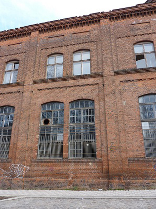
The smallest of the three facades, the east facade, has several facade jumps and sloping facade parts, which increased the effort of surveying and evaluation. With the help of laser scanning, the facade details, such as window openings and wall protrusions, could be captured with high accuracy.
Orthophotos were automatically generated from the laser scanning survey results using PointCab Origins. Using the true-to-scale PointCab Origins images, the data was imported into Geograf within an hour. This resulted in detailed orthophotos and structured, digital 2D plans of the facades, including the cracks in the east facade. Modeling can now be carried out in the generated views and sections of the 3D CAD model, which simplifies planning for the renovation and conversion work.
The facts again at a glance: The three facades of the building complex were captured by laser scanner. The data was evaluated with PointCab Origins and Geograf at a scale of 1:50. A total of 25 laser scanner locations were used to measure the 1,720 m² of the facade. Only one employee was needed for the survey, which took only 5 hours. One of the advantages of PointCab Origins was the fast generation of the othophotos. Within one hour, 3 GB of data could be processed. This resulted in true-to-scale and detailed images. Reading in and further processing of the data in the CAD system Geograf was possible without any problems. Thanks to the quickly generated Othofotos, the evaluation in Geograf was a piece of cake. In total, the project was completed within 35 working hours from the first scan.
WHY POINTCAB ORIGINS?
Software speed
Even the most extensive point cloud data can be evaluated easily and quickly with PointCab Origins.
Direct workflow to Geograf
The information of the evaluated point cloud data can be used easily and quickly in the CAD system Geograf.
Proximity to support
PointCab’s support is characterized by comprehensive expertise and individual attention.
About Laserscanning Europe
Laserscanning Europe is the leading system company for 3D laser scanning. As an independent and experienced partner, we can offer our customers the best project solution for their application.
By renting and selling laser scanning hardware, software and accessories, we provide our customers with the required tools for their projects. In our training courses, we share our know-how and many years of experience from various projects. On demand, we support our customers with data collection by means of 3D scanners, analysis of scan data and modeling.