Plant documentation in gas supply

kessel

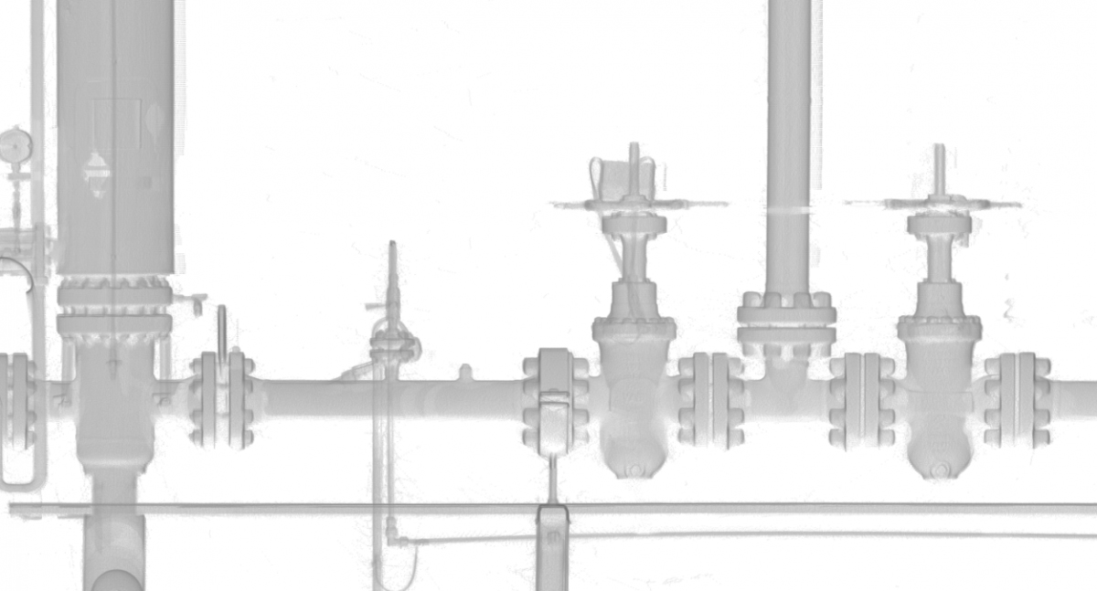
Acquisition of complex piping systems – Export of precise dimensions

Niederreihnische Gas-Technik GmbH (NieGaTec) is a partner of the energy industry. Managing Director Klaus Jäger invested in the acquisition of a laser scanner in 2010 in order to improve his measurements. The complex pipeline structures in particular can be optimally recorded with the laser scanner. After purchasing the hardware, the question arose as to the optimal software for the rapid evaluation of the measurements. In the utility industry, 2D plans still dominate as a basis for work. Pipe runs are represented by line connections and gate valves, valves and other installations are indicated by symbols. Therefore, it was important for NieGaTec to quickly convert the 3D measurements back into layouts and sections.

After researching the market, the professionals chose PointCab Origins software because its ease of use and layout representation best met the needs of the gas industry. The layouts are read into AutoCAD through the PointCab Origins CAD export and drawn up by the staff. In this process, the symbol libraries developed by NieGatec can be used in their entirety. The interaction of laser scanning technology and PointCab Origins now enables NieGatec GmbH to guarantee its customers fast and precise measurements.

WHY POINTCAB ORIGINS?

Software speed

Even the most extensive point cloud data can be evaluated easily and quickly with PointCab Origins.

Direct workflow to AutoCAD

The information of the evaluated point cloud data can be easily and quickly transferred to AutoCAD.

Proximity to support

PointCab’s support is characterized by comprehensive expertise and individual attention.

Simply ingenious software for creating piping plans from our laser scanning projects.
Niederrheinische Gas-Technik GmbH
Jun. 2013

About Niederrheinische Gas-Technik GmbH

Niederreihnische Gas-Technik GmbH (NieGaTec) is a partner of the energy industry. The company provides versatile engineering services for utilities in the energy industry. These include many municipal utilities and gas suppliers. For the documentation and planning of plants, an as-built survey is indispensable. This often involves gas distribution systems, gas pressure regulating stations (GDR) and gas pressure regulating metering stations (GDRM). www.niegatec.de

Surveying Dunelm House

dunelm house

Dunelm House: Why a Precise 3D Survey Was Needed

Dunelm House (1966) is Durham University’s well-known students’ union building. Designed in the post-war modernist style, it sits directly on the steep banks of the River Wear. Furthermore, it is connected to the equally iconic Kingsgate Bridge.

The structure is characterized by exposed concrete and terraced floor levels. A multi-angled, irregular roofscape follows the natural slope of the riverbank. This bold design makes Dunelm House architecturally significant  – and challenging to measure.
When leaks appeared across several roof areas, a detailed digital survey was needed. The aim was to document the current condition and guide the renovation.

The Challenge: Complex Roof and Difficult Site Conditions

The student building’s roof consists of intersecting levels, changing slopes, and unconventional angles. Combined with its sloping riverside location, this makes traditional measurement methods unreliable and slow.

To capture the structure accurately and efficiently, the project required a modern surveying approach capable of documenting every plane and surface with precision.

How the Survey Was Completed: Laser Scanning + GPS

The survey was carried out by Bury Associates Ltd using two FARO Focus3D laser scanners. To record the terrain and ensure accurate referencing across the entire site, the team also used total stations and GPS equipment.

This hybrid surveying method made it possible to capture:

  • the full exterior geometry of Dunelm House,
  • its complex multi-level roof structures,
  • and high-precision topographic context along the River Wear.

The result was a detailed point cloud covering the entire building and its surroundings.

We think PointCab Origins is the fastest way to extract plans and sections from point clouds.
Bury Associates Limited
Dez. 2018

From Point Cloud to 3D Model: Deliverables in Four Days

After the scanning process, the data was processed using PointCab Origins, which enabled the team to deliver complete documentation in just four days.
The deliverables included:

  • orthophotos,
  • 2D floor plans,
  • sections and elevations,
  • and a full 3D Revit model created from the processed Origins data.

By exporting PointCab’s results into Autodesk Revit, the project team gained a BIM-ready model with the accuracy needed to analyse the leaking roof and plan the renovation.

How the Digital Survey Supports the Renovation Process

The Dunelm House project shows how 3D laser scanning, precise site measurement, and point cloud processing can deliver fast, reliable results — even for buildings with complex shapes and challenging site conditions.

With the combination of FARO scanners, survey instruments, and PointCab Origins for evaluation, Bury Associates delivered a complete set of renovation-ready outputs, including a detailed Revit model.
This provided architects and engineers with a solid digital foundation for repairing and preserving one of Durham’s most distinctive architectural landmarks.

Want to keep up with the latest pointCab news?

Then follow us on Social Media or subcribe to our newsletter!