Acquisition of a high school

blank

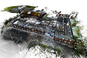
New construction and modernization of a high school on the west coast of England

For the new construction and modernization of Skegness Academy, a high school in Lincolnshire on the west coast of England, an accurate as-built model was required.

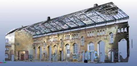
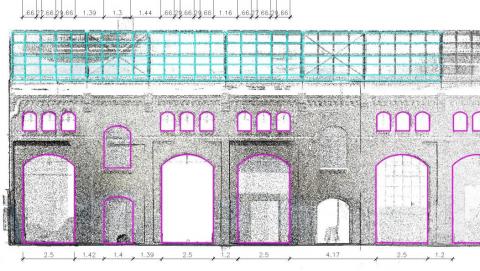
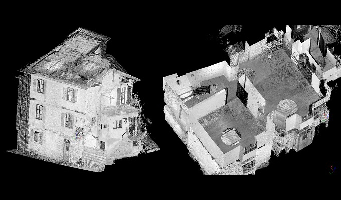
In order to obtain the exact dimensions of the high school, the FARO Photon 120 laser scanner was used, which can capture up to 990,000 points per second. With the help of reference points in the individual scans, they could later be merged. The scans were then used to generate a dimensionally accurate point cloud that provided an accurate 3D model of the building.

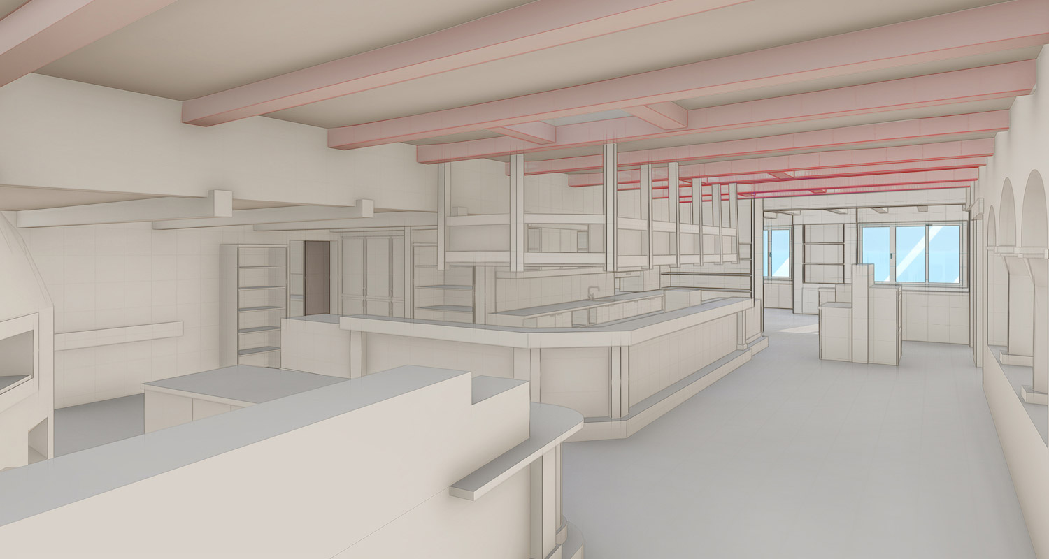
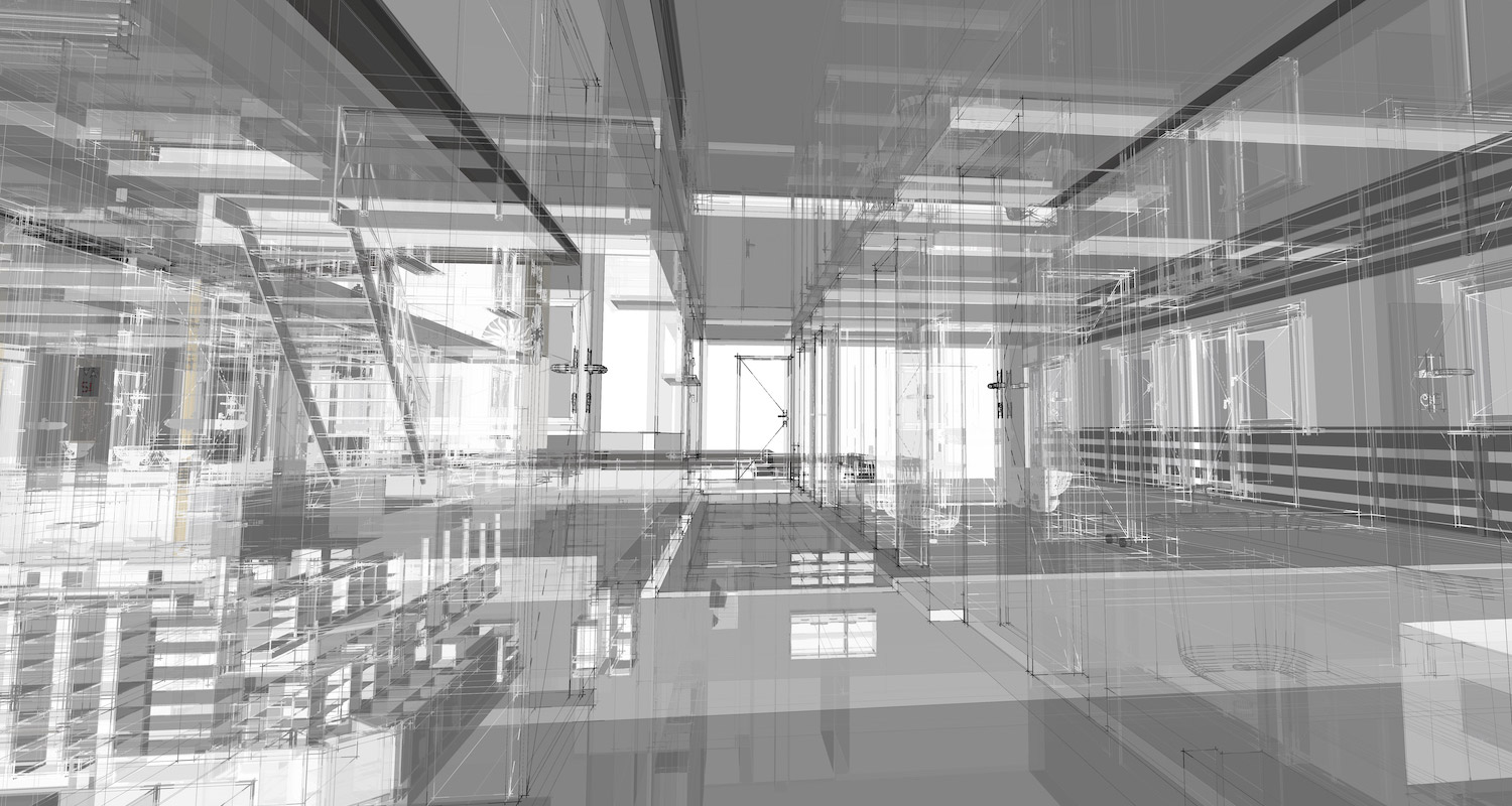
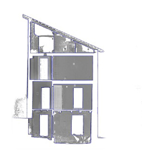
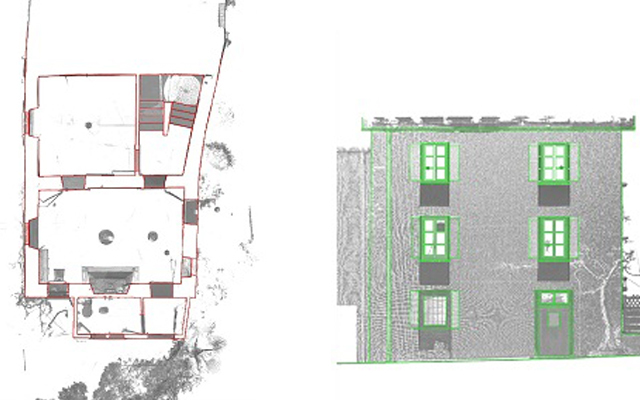
For the project, PointCab Origins was used to create elevations and sections, as well as detailed, dimensionally accurate images. This allowed various views of the high school to be generated and read into Autodesk Revit. A complete 3D model was then created with just the click of a button.

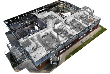
The FARO Photon 120 delivered 230 scans here. Images of the entire site and the building from the inside were taken. The views were imported into Autodesk Revit. From this data, a highly accurate 3D model of the building was created.
What advantage did PointCab Origins bring here? The fully automatic generation of views and sections. Likewise, accurate and true-to-scale images were used here. The further processing of the scan data in the CAD system was also possible without plug-ins thanks to PointCab Origins. This provided the optimal basis for modeling, visualization, processing and simulation.

WHY POINTCAB ORIGINS?

Software Speed

Even the most extensive point cloud data can be evaluated easily and quickly with PointCab Origins.

Direct workflow to Revit

The information of the evaluated point cloud data can be easily and quickly transferred to Revit.

Proximity to support

PointCab’s support is characterized by comprehensive expertise and individual attention.

We think PointCab Origins is the fastest way to extract plans and sections from point clouds.
Eric Bergholz
CEO Laserscanning Europe
Jun. 2013

About Laserscanning Europe GmbH

Laserscanning Europe is the leading system company for 3D laser scanning. As an independent and experienced partner, we can offer our customers the best project solution for their application.

By renting and selling laser scanning hardware, software and accessories, we provide our customers with the required tools for their projects. In our training courses, we share our know-how and many years of experience from various projects. On demand, we support our customers with data collection by means of 3D scanners, analysis of scan data and modeling.

https://www.laserscanning-europe.com

BIM model of a hotel in St. Moritz

blank

From scan to BIM on the fly – HMQ scans luxury hotel in St. Moritz

The Hotel Sonne in St. Moritz is a popular destination for skiing and Welness vacationers. To prepare the hotel for the future, HMQ AG was commissioned to generate a comprehensive 3D building model of all interior spaces and the exterior facade. The 3D point cloud data was required for further processing in Graphisoft Archicad to create a complete BIM model.

Right from the start, the project included a major challenge: the acquisition of the hotel with laser scanners from FARO had to take place during the peak winter season and also during ongoing guest operations. The entire building therefore had to be captured as quickly as possible and without major disruption to guests. In the interior, a floor area of 1,100 m² had to be surveyed, distributed over three floors and a building height of approx. 10 meters. Outside, the work was no easier. The snow lying at the time of the project, which is why vacationers primarily traveled to St. Moritz, made the scans of the facade difficult.

HMQ, however, managed all challenges and had a huge amount of point cloud data from around 500 scans after only 72 hours. HMQ has been using Archicad 21 software to create BIM models for some time. To be able to use the point cloud data for processing in Archicad, HMQ uses PointCab Origins. More specifically, use the 4BIMm plugin, which allows the point clouds to be analyzed and the information seamlessly transferred into ArchiCAD. This reduced time for HMQ and, consequently, project costs. Putting all this together, the result was a relaxed project process for everyone involved. This can only be beneficial for a vacation hotel.

The basis for this is the uniquely fast processing of the most extensive point clouds in PointCab Origins. Ease of use was the main focus when Christian Vetsch, Managing Director at HMQ together with his team decided to use PointCab Origins three years ago. The great compatibility with all scanner types and makes made the decision even easier for HMQ.

“We chose PointCab Origins because the software is easy and intuitive to use and is constantly being developed,” says Christian Vetsch. If you ask HMQ employees, they also appreciate the uncomplicated proximity to PointCab support.

WHY POINTCAB ORIGINS?

Software Speed

Even the most extensive point cloud data can be evaluated easily and quickly with PointCab Origins.

Direct workflow to ArchiCAD

The information of the evaluated point cloud data can be easily and quickly transferred to Graphisoft ArchiCAD.

Proximity to support

PointCab’s support is characterized by comprehensive expertise and individual attention.

We chose PointCab Origins because the software is easy and intuitive to use and is constantly being developed
Christian Vetsch
Managing Director HMQ AG
Dez. 2018

About HMQ AG

HMQ AG, based in the cantons of Graubünden, Zurich and Aargau, is one of the leading Swiss engineering and planning companies.
The core competencies of the engineers, planners and consultants of the HMQ Group lie in the specialist areas of surveying, construction and planning. To ensure customer satisfaction as well as to offer employees an exciting work environment, HMQ AG builds on innovation, quality and technology.
To the HMQ AG website: http://hmq.ch/

3D rendering of a historic commercial hall

blank

Laserscanning Architecture uses PointCab Origins in AutoCAD Architecture

The company Laser Scanning Architecture used the FARO 3D laser scanner for the three-dimensional acquisition of a historic commercial hall. The 3D data created was evaluated using AutoCAD Architecture and PointCab Origins. The scan data was analyzed in both photo mode and pixel mode using FARO Scene software. In the model, analyses and geometric allowances were performed in colored panoramic views. Perspectives could be freely selected and partial areas of the model could be hidden as desired.

Using PointCab Origins, a 2D analysis was realized in AutoCAD Architecture. For this purpose, orthographic 2D views of the existing structure were created from any position in the model using PointCab Origins. This laid the foundation for efficient replanning. The advantages were: orthographic 2D images of the inventory, as well as freely selectable positions in the scan. The inventory could be quickly captured in detail (cornices, stone formats, etc.). The resulting highly accurate dimensioning, formed the basis for efficient redesign, including overdrawing of component edges. PointCab Origins results were used to create plans, elevations, sections and 3D BIM models. Images could be extracted from the point cloud. The client was able to quickly view and use the information thanks to the web export.

WHY POINTCAB ORIGINS?

Software Speed

Even the most extensive point cloud data can be evaluated easily and quickly with PointCab Origins.

Direct workflow to AutoCAD

The information of the evaluated point cloud data could be easily and quickly transferred to AutoCAD.

Proximity to support

PointCab’s support is characterized by comprehensive expertise and individual attention.

Fast point cloud evaluation with PointCab Origins and Autodesk AutoCAD Architecture.
Laser Scanning Architecture
Jun. 2013

About Laser Scanning Architecture

As a formerly classic architectural office, we specialized in 3D laser scanning in 2010. Since then, the demand has increased so much that we are now only active in 3D surveying. Managing director Johannes Rechenbach has a working experience of more than 30 years as a freelance architect and has been running his own architectural office in Hannover for 20 years.

During this time, we have learned many times that a thorough survey of the existing building is always the basis for a successful remodeling project. The precise laser scanning therefore offers the perfect basis for all projects of building in existing contexts. https://www.laser-scanning-architecture.com

As-built documentation of an old house

As-Built Documentation of an Old House: Why a Complete 3D Laser Scan Was Essential

An old residential building in a village in the Swiss canton of Ticino lacked reliable, up-to-date building plans. To prepare renovation and restoration work, the engineering firm Geomatica Righitto (Lugano, Switzerland) was commissioned to do a full 3D as-built documentation.

Traditional plans were missing or outdated, and the building required precise measurements to support planning in CAD and BIM software.

Missing Plans, Irregular Geometry, and the Need for Precision

Older buildings rarely follow perfectly straight lines or standardized geometries. Over decades – or even centuries – walls may shift, floors may sag, and angles deviate from 90 degrees.

This means: assumptions based on symmetry or “standard” geometry can be highly misleading.

For renovation work, especially structural or restorative interventions, accurate data is crucial. Because no reliable plans existed for this house and its geometry was visibly irregular, a precise and complete measurement was essential, making 3D laser scanning the ideal method.

Survey: Faro Photon 120, Faro Scene, and Efficient On-Site Work

Geomatica Righitto used a FARO Photon 120 laser scanner to capture the entire building, including:

  • three façades,
  • the basement,
  • the roof,
  • and all four floors.

In total:

  • 29 scans,
  • 6 hours on site,
  • 3 survey specialists.

All scans were registered and merged in FARO Scene, ensuring correct alignment and a unified, consistent point cloud.

This point cloud became the complete digital representation of the building, including all the irregularities typical of older structures.

Point clouds are for engineers, plans for architects. PointCab Origins is the fastest connection between them.
Marzio Righitto
Engineer - Pastorelli SA
Dez. 2018

Processing the Point Cloud: Fast Extraction of Plans and Sections

Once the unified point cloud was ready, Geomatica Righitto used PointCab Origins to extract essential architectural outputs:

  • 4 floor plans
  • 3 façade plans
  • 20 building sections
  • Orthophotos for façades and interior walls

These automated extractions significantly reduced manual drafting work.
The final drawings — both as-built documentation and renovation plans — were delivered in a CAD/BIM-ready format for use in Archicad.

The entire processing workflow, including preparation for delivery, took about 8 hours.

What This Case Study Demonstrates

This project shows how even older buildings with irregular geometry and missing documentation can be comprehensively captured. Old buildings are rarely dimensionally perfect, but laser scanning captures reality exactly as it is, and the resulting point cloud becomes a trusted digital baseline.

The combination of FARO Photon 120, FARO Scene, and PointCab Origins enabled Geomatica Righitto to create reliable plans quickly –  giving architects and engineers the confidence they need to design renovations and restoration work effectively.

Want to keep up with the latest pointCab news?

Then follow us on Social Media or subcribe to our newsletter!